The Tibetan Plateau (TP), often referred to as the 'Asian Water Tower', plays a critical role in regulating the hydrological cycle and influencing global climate patterns. Its unique topography and climatic conditions result in pronounced seasonal freeze-thaw (FT) dynamics of the land surface, which are critical for understanding permafrost ecosystem responses to climate change. However, existing studies on FT dynamics over the TP are limited by either short observational periods or deficiency in accuracy, failing to capture the long-term FT processes comprehensively. This study presents a novel satellite-based approach for monitoring the FT dynamics over the TP from 1979 to 2022, utilizing passive microwave observations. We developed a new algorithm that integrates discriminant function algorithm (DFA) with a seasonal threshold algorithm (STA), employing the freeze-thaw index (FTI) as the classification variable to determine optimal FT thresholds. The strong performance of the algorithm was confirmed by in-situ validation, with an overall accuracy of 91.46%, a Kappa coefficient of 0.83, and an F1-score of 0.92, outperforming other remote sensing-derived FT products such as SMAP (OA = 89.44%, Kappa = 0.79, F1 = 0.89). Results reveal significant changes in surface freeze-thaw dynamics over the past four decades. Between 1988-2022, frozen days exhibited a significant decreasing trend of -0.19 daysyear(-)(1), primarily attributed to the delayed freeze onset (0.19 daysyear(-)(1)), while thaw onset showed no significant trend. Spatially, permafrost regions experienced a more pronounced decrease in frozen days and earlier thaw onset compared to seasonally frozen regions. Moreover, marked interannual trend differences in FT processes were observed across elevation gradients, with higher elevations showing more negative trends in frozen days and thaw onset. This study provides a reliable and up-to-date analysis of surface FT process changes over the TP, informed by long-term satellite-based observational perspectives. These analyses revealed marked spatial heterogeneity in surface FT dynamics across the TP region, underscoring the impacts of climate change on the cryosphere and hydrology.
Climate change is reshaping the risk landscape for natural gas pipelines, with landslides emerging as a major driver of technological accidents triggered by natural hazards (Natech events). Conventional Natech risk models rarely incorporate climate-sensitive parameters such as groundwater levels and soil moisture, limiting their capacity to capture evolving threats. This study develops a probabilistic model that explicitly links climate-driven landslide susceptibility to pipeline vulnerability, providing a quantitative basis for assessing pipeline failure probability under different emission projection scenarios. Using Monte Carlo simulations across five regions in China, the results show that under high-emission pathways (SSP5-8.5), pipeline failure probability in summer increases dramatically. For example, from 0.320 to 0.943 in Xinjiang, 0.112 to 0.220 in Sichuan, and 0.087 to 0.188 in Hainan. In cold regions, winter failure probability more than doubles, rising from 0.206 to 0.501 in Heilongjiang and from 0.235 to 0.488 in Beijing. These shifts reveal an overall increase in risk, intensification of seasonal contrasts, and, in some areas, a reconfiguration of high-risk periods. Sensitivity analysis highlights groundwater levels and soil moisture as the dominant drivers, with regional differences shaped by precipitation regimes, permafrost thaw, and typhoon impacts. Building on these insights, this study proposes an AI-based condition-monitoring framework that integrates real-time climate and geotechnical data to support adaptive early warning and safety management.
Study region The eastern Qilian Mountains, located on the northeastern margin of the Tibetan Plateau, span elevations from similar to 2600 to 5300 m around the Menyuan area. It is characterized by cold, alpine climatic conditions and hosts both permafrost and seasonally frozen ground, which are highly sensitive to climate change and have important hydrological and ecological implications. Study focus This study develops an enhanced multi-temporal InSAR framework to monitor frozen ground dynamics in the eastern Qilian Mountains using Sentinel-1 data from 2014 to 2024, with a particular focus on the permafrost-seasonally frozen ground transition zone around Menyuan. It addresses key challenges in permafrost monitoring by implementing a co-seismic deformation separation model, a Common Scene Stack (CSS)-based atmospheric correction method, and a time-series decomposition model with linearly varying annual amplitude to capture evolving freeze-thaw behavior under climate change. New hydrological insights for the region The results reveal clear hydrological and thermal contrasts between permafrost and seasonally frozen ground. Seasonally frozen ground exhibits higher seasonal deformation amplitudes, more rapid interannual changes, and shorter thermal response lags compared to permafrost, reflecting its more dynamic hydrothermal regime. The estimated freeze-thaw layer thickness ranges from 0 to 5.3 m, with thinning trends in seasonally frozen ground at lower elevations and slight thickening of active layers in high-elevation permafrost. These findings highlight ongoing frozen ground degradation and provide new insights into subsurface water-energy interactions and long-term cryospheric responses to climate warming in alpine environments.
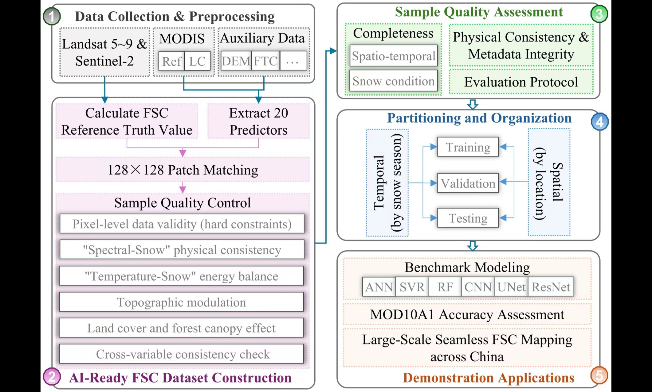
积雪覆盖率(FSC)是冰冻圈与陆气界面能量、水分交换的关键变量,在水文预报、水资源管理、气候变化监测等领域发挥着重要作用。传统FSC反演方法在复杂地形、高植被覆盖区域精度受限,而新兴的机器学习与深度学习FSC估算方法虽能捕捉高维非线性关系,但因缺乏大规模、标准化、跨区域的人工智能就绪(AI-Ready)FSC数据集,且无统一的数据集构建标准流程和评估规范,难以在大尺度、长时序FSC监测中充分发挥效能。因此,构建符合AI-Ready标准的FSC数据集,已成为推动人工智能驱动积雪监测研究取得突破的关键。 中国科学院西北生态环境资源研究院研究团队利用多源卫星遥感数据(Landsat-5/7/8/9、Sentinel-2及中分辨率成像光谱仪(MODIS))与多维度环境要素,构建了大规模、标准化、面向人工智能应用的积雪覆盖度样本数据集——ChinaAI-FSC。该数据集建立了系统的数据集构建标准流程与科学的评估规范,通过多源数据融合、严格质量控制、标准化组织,形成了高质量、可复用的AI-Ready样本库。 ChinaAI-FSC包含47,728个高质量样本,每个样本为128×128 MODIS像元瓦片,参考真值由Landsat-5/7/8/9和Sentinel-2高分辨率影像生成,覆盖中国全部陆地范围及三大稳定积雪区。数据集提取了20个特征变量,包括MODIS地表反射率(波段1–7)、地形属性、森林与土地覆盖信息及地理位置因子,可同时支持基于“点”和“面”两种人工智能建模范式。 在质量控制方面,研究建立了像素和瓦片两级综合质量控制体系,从光谱—积雪物理一致性、温度—积雪能量平衡一致性等多维度进行严格筛选。提出了“四层—四域—十五属性(4L-4D-15A)”人工智能就绪性评估协议,从数据、信息、系统、应用四个维度全面评估数据集。 该评估体系也可推广应用于土壤湿度、植被、地表温度等其他地球物理变量研究中。ChinaAI-FSC的构建,为人工智能驱动的大尺度、长时序积雪覆盖监测提供了高质量数据基础,推动了相关算法的可复现与互操作,有望显著提升复杂地表条件下积雪覆盖度反演的精度与泛化能力。 研究成果以ChinaAI-FSC: A Comprehensive AI-Ready MODIS Fractional Snow Cover Dataset for China (2000-2022)为题发表在国际期刊Earth System Science Data上。数据集发布在国家冰川冻土沙漠科学数据中心,用户可开放获取。西北研究院侯金亮副研究员为论文第一作者,张莹副研究员、黄春林研究员为共同通讯作者。该研究得到国家自然科学基金等项目资助。 论文链接:https://doi.org/10.5194/essd-18-1995-2026 数据集链接:https://www.ncdc.ac.cn/portal/metadata/e44b23cc-0aad-43ec-90c5-9eb1882c696f
2026-03-25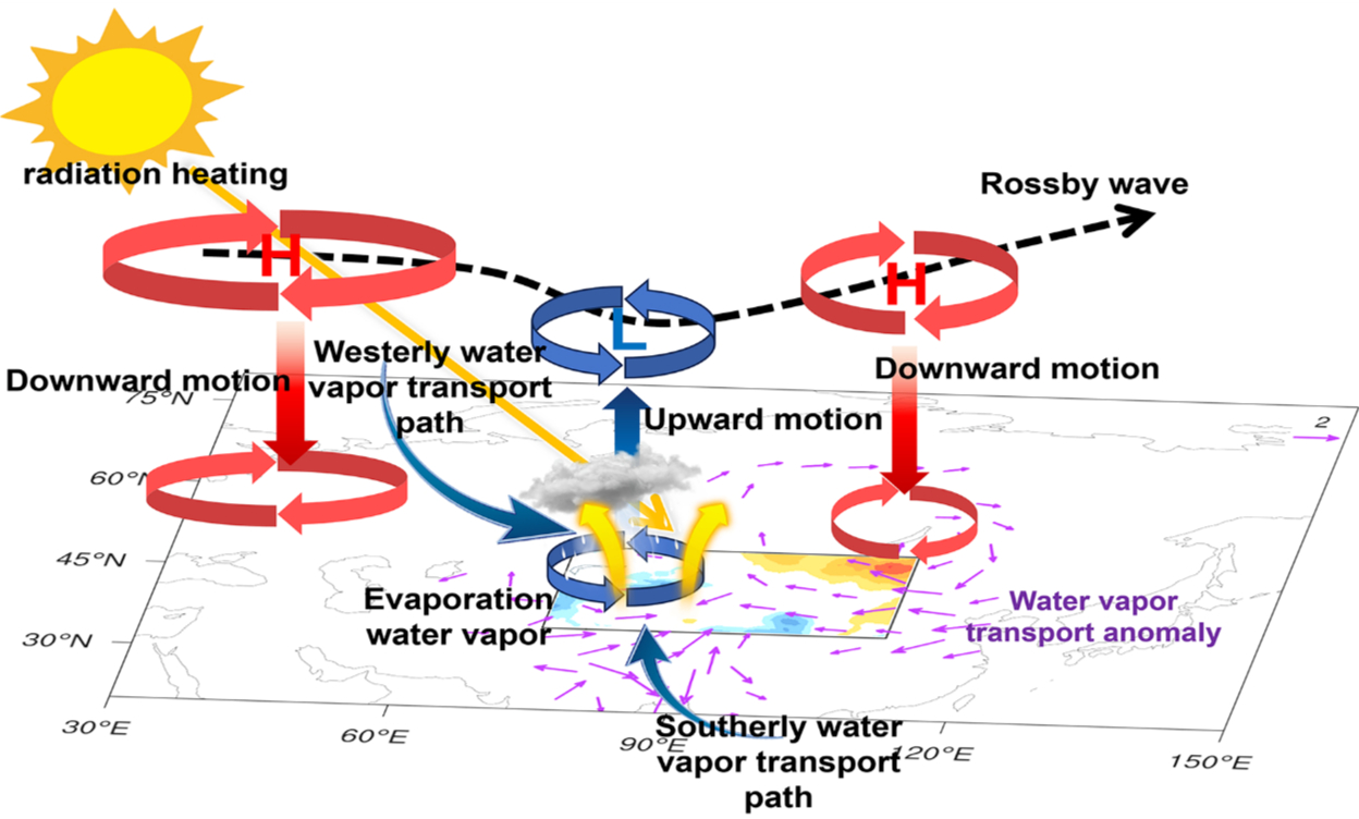
近年来,中国西北干旱区出现的暖湿化现象备受关注。然而,增多的水汽来源及变湿趋势能否持续等问题,一直存在争议。中国科学院西北生态环境资源研究院科研团队联合兰州大学等多家单位,揭示了我国西北地区暖湿化水汽来源及驱动机制。 研究表明,1961至2020年间,中国西北夏季降水变化在空间上呈现“西增东减”的区域差异,且20世纪末是一个关键转折点,降水量由此前的下降趋势转为持续的上升趋势。与1961至1997年相比,1998至2020年西北地区年降水量平均增加了约10.62毫米,增幅约9.18%。 为厘清水汽来源,研究团队运用动态降水再循环模型(DRM)进行量化分析。结果显示,在降水增量中,由本地蒸散发(土壤蒸发、植物蒸腾)增强形成的再循环水汽贡献率高达78%,远超外界水汽输送22%的贡献率。同期区域年蒸散发量增加10.42毫米,增幅约9.12%。结果表明,尽管长期气候平均状态下西北降水的水汽一半以上依赖外部输入,但近几十年来的湿化趋势,主要是由局地水循环过程增强所驱动。气温上升、冰雪融水补给增加以及植被恢复等因素共同提升了区域蒸散发能力。 研究进一步揭示,大尺度气候背景场变化为局地水循环增强提供了有利条件。当前处于正相位的北大西洋多年代际振荡(AMO),通过激发跨欧亚大陆的罗斯贝波列,增强西北地区上空水汽辐合、抑制水汽向东输出,为降水增加创造了关键动力条件。 研究指出,尽管当前西北地区处于降水显著增加阶段,但这一过程可能具有波动性,未来趋势存在较大不确定性。作为关键驱动力的AMO未来转为负相位时,可能导致西北降水增加趋势发生调整。另外,支撑蒸散增强的冰川积雪等“固态水库”储量有限,在气候增暖背景下,随着冰川持续消融,依赖冰雪融水的蒸散过程可能显著减弱,从而削弱区域湿化进程。 该研究成果以Local evapotranspiration and Atlantic decadal variability dominate the humidification of Northwest China为题,发表在国际期刊Advances in Atmospheric Sciences上。西北研究院于海鹏研究员为论文第一作者,兰州大学黄建平院士为通讯作者,中国气象局兰州干旱气象研究所张强院士为主要参与作者。研究得到国家自然科学基金气象联合基金重点项目、中国科学院“西部之光-西部交叉团队”重点实验室专项等资助。 论文链接:https://www.iapjournals.ac.cn/aas/article/doi/10.1007/s00376-025-5414-5 西北干旱区“湿化”机制图 (a)西北干旱区水分收支图(图中数据分母为1998–2020年夏季各变量的多年平均值,单位为10⁵ kg/s;分子表示1998–2020年平均值相较于1961–1997年平均值的增加量。其中,Fin为水汽流入量,Fout为水汽流出量,Fout-a和Fout-e分别表示由水平水汽输送与局地蒸散发产生的流出水汽;Pa为外部平流水汽形成的降水,Pe为再循环降水,P为总降水;E为蒸散发);(b)西北干旱区夏季不同降水类型对比(1961–1997年与1998–2020年平均值;上行:1961–1997年,下行:1998–2020年;红色:再循环降水,蓝色:外循环降水,绿色:残余项;数值表示各类型水汽占同期总降水的百分比)。
2026-03-09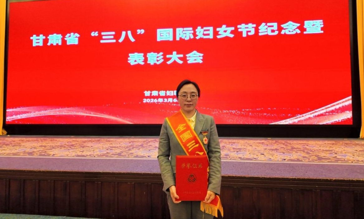
3月6日,在第116个“三八”国际妇女节来临之际,甘肃省妇女联合会举行纪念表彰大会,公布全国妇联授予的2025年度全国三八红旗手标兵、全国三八红旗手、全国三八红旗集体等荣誉名单。中国科学院西北生态环境资源研究院孟宪红研究员被授予“全国三八红旗手”称号。 孟宪红,研究员,博士生导师,西北研究院院务委员、党委委员,高原大气物理研究室主任,中国科学院若尔盖高原湿地生态系统研究站站长。主要从事寒旱区陆面过程观测、模式发展及区域气候变化研究。她扎根科研一线,发表学术论文140余篇,主持国家自然科学基金青年基金项目(A类、B类)、重点项目、中国科学院战略先导专项项目、国家重点研发计划课题等多项重点任务。先后入选中国科学院青年创新促进会优秀会员、甘肃省领军人才,荣获中国科学院2019年度感动人物、第二届中国科学院三八红旗手、甘肃省优秀专家、甘肃省科技进步二等奖等多项荣誉,当选甘肃省第十四次党代会代表。 作为“世界屋脊上的气象人”,孟宪红面向“黄河流域生态保护和高质量发展”国家重大需求,以“中华水塔”生态环境保护与气候变化应对为使命,牵头建成黄河源区“一站八场”式“水-土-气-生”综合观测网络,搭建起复杂地形下多圈层相互作用监测平台。依托长期监测数据,她带领团队发布了支撑黄河流域生态保护与高质量发展的体系化专题数据,为黄河流域生态状况调查评估、生态修复民主监督等工作提供了有力支撑。同时,她带领团队研发了适用于寒旱区的区域气候和数值水文模式,建成了全球水文数据云平台及兰州市暴雨洪涝灾害风险预警平台,为可重复水文建模和大范围实时水情模拟与预报开辟了新路径。研究成果有效支撑了多学科交叉、行业应用等多元需求。 据悉,此次全国妇联共授予9人全国三八红旗手标兵、598人全国三八红旗手、400个全国三八红旗集体、600个全国巾帼文明岗。孟宪红获此殊荣,既是对其个人科研成就与奉献精神的高度肯定,更激励广大女性科研工作者在岗位上迎难而上、砥砺前行,为西北研究院高质量发展、我国寒旱区生态环境保护事业贡献巾帼力量。 颁奖现场
2026-03-09
气候变暖背景下,多年冻土加速退化改变了寒区流域的产汇流过程与生态水分格局。作为连接冰冻圈水文建模与生态评估的关键变量,多年冻土深层土壤水分的垂向结构与空间异质性研究长期受两方面制约:一是卫星遥感对土壤水分的有效探测深度主要局限于地表浅层(约0–5 cm),二是深层剖面观测数据稀缺,导致寒区流域在垂向维度上的高分辨率水分分布规律及其主控机制难以被有效刻画。 中国科学院西北生态环境资源研究院胡国杰研究员团队联合南京信息工程大学、兰州大学等单位,以我国大兴安岭根河流域这一典型边缘多年冻土区为研究区域,围绕植被-水分-冻土相互作用过程及数据产品研发开展系统研究,取得了从原位观测机理到全流域精细制图的系列进展。 研究团队在根河流域布设75个浅层土壤剖面和15个深达20米的钻孔,获取了覆盖森林、草地、湿地等不同下垫面的土壤含水量观测数据。并结合可解释机器学习与结构方程模型,系统揭示了边缘多年冻土区土壤水分的“垂向分层”特征及其控制机制。 研究结果显示,湿地覆盖、土壤有机碳等地表与土壤属性主导了浅层水分分布,土壤容重和多年冻土分布控制了深层蓄水与水分维持。气候因子则主要通过改变地表温度条件与冻融过程,间接影响水分结构与分层格局。 该研究系统提出了边缘多年冻土区土壤水分的“垂向分层控制体系”概念框架,为完善多年冻土水文过程认识提供了关键实地依据。 在上述观测数据和机制认识的基础上,团队研发了一套融合对地观测大数据与可解释机器学习的制图算法,绘制了全流域0–1 m深度、10 cm间隔、30 m分辨率的土壤水分分层数据产品。 该数据产品表现优异(R2 = 0.85, RMSE = 0.08 L/L),能精准刻画冻土与湿地共同塑造的“河谷湿润走廊”及干燥高地的空间分异,弥补了SMAP等全球粗分辨率产品难以解析深层与亚公里尺度异质性的不足,为寒区流域水文模拟与生态管理提供了可移植的制图方案与高精度基础数据。 相关成果分别以Vegetation and permafrost interactions shape soil moisture stratification in marginal permafrost zones与Earth observation and machine-learning–based mapping of 0–1 m soil moisture at 10-cm intervals in a permafrost-affected basin为题,发表在国际期刊Geoderma与International Journal of Applied Earth Observation and Geoinformation(JAG)。西北研究院肖瑶助理研究员为第一作者,胡国杰研究员为通讯作者。研究得到科技部基础资源调查专项、国家自然科学基金、中国科学院青年创新促进会及冰冻圈科学与冻土工程全国重点实验室等项目联合资助。 论文链接: 1. https://doi.org/10.1016/j.geoderma.2025.117596 2. https://doi.org/10.1016/j.jag.2026.105147 根河流域土壤含水量样点分布及野外采样示意图 根河流域土壤含水量垂直分布特征 边缘多年冻土区水分垂向耦合机制概念框架图 全流域高分辨率根区土壤水分、多年冻土和植被类型分布图 不同深度层模型精度与基于SHAP的可解释性分析结果
2026-03-04 中国科学院西北生态环境资源研究院Rapid climate change in the Northern Hemisphere cryosphere threatens ancient permafrost carbon. Once thawed, permafrost carbon may migrate to surface waters. However, the magnitude of permafrost carbon processed by northern freshwater remains uncertain. Here, we compiled '1800 radiocarbon data of aquatic dissolved organic carbon (DOC) and particulate organic carbon (POC) in the Arctic and Qinghai -Tibet Plateau (QTP) to explore the fate of permafrost carbon under climate warming over the past 30 years. We showed that the contribution of aged carbon has significantly increased since 2015. Approximately 70 % of DOC and POC was derived from aged carbon for QTP rivers. In Arctic waters, an average of '67 % of POC was derived from aged carbon, however, '75 % of DOC was derived from modern carbon, mainly due to low temperatures and protection by vegetation limiting the export of aged DOC. For both regions, DOC 14 C age was positively correlated with the active layer thickness, whereas the POC 14 C age was positively correlated with the mean annual ground temperature, suggesting that gradual thaw accelerated the mobilization of aged DOC while abrupt thaw facilitated the export of aged POC. Furthermore, POC 14 C age was positively correlated with the soil organic carbon density, which was attributed to well-developed pore networks facilitated aged carbon output. This study suggests that permafrost carbon release is affected by both permafrost thermal properties and soil organic carbon density, which should be considered in evaluation of permafrost carbon -climate feedback.
Black carbon (BC) mixed with non-BC components strongly absorbs visible light and leads to uncertainty in assessing the absorption enhancement (Eabs) and thus radiative forcing. Traditional Single-Particle Soot Photometer (SP2) combined with the leading-edge only fitting (the only-SP2 method) derives BC's mixing states through Mie scattering calculations. However, errors exist in retrieved optical diameter (Dopt) and MR due to the assumption of the ideal spherical core-shell structure and the selection of the calculation parameters like density and refractive index (RI) of the components. Here, we employed a custom-developed tandem CPMA-SP2 system, which classifies fixed-mass BC to characterize the mixing state, then compared with the only-SP2 method in quantifying the mixing state and Eabs. The field measurements show that the SP2 demonstrates variability in assessing the mixing state of BC in different aging states. The thickly-coated particles with small core approaching the internally mixed state are more sensitive to the change of calculated RI. The Dopt decreases with the RI increasing, indicating that this method accurately measures both Dopt and Eabs when a reasonable refractive index is selected for calculation. However, for thinly-coated particles with moderate or large core, this method results in significant deviations in the computed Eabs (errors up to 15 %). These deviations may be caused by the various shapes of BC and systematic errors. Our results provide valuable insights into the accuracy of the SP2-retrieved Dopt and MR based on Mie calculations and highlight the importance of employing advanced techniques for further assessment of BC's mixing state.