The Third Pole region, encompassing the vast Himalayan and Tibetan Plateau, is undergoing rapid cryosphere and ecological transformations. This review synthesizes findings from 93 peer-reviewed studies (2000-2024) to evaluate the interactions between glacier retreat, permafrost degradation, and material cycling (carbon, methane, and nitrogen). Mean air temperature has increased by 0.3-0.4 degrees C per decade, while glaciers have lost nearly 36% of their area since the 1990s. Permafrost active layer thickness has deepened by more than 50%, releasing carbon dioxide (CO2), and methane (CH4) previously locked in frozen soils into the atmosphere and water systems. Methane fluxes from wetlands, lakes, and hydrates amplify warming feedback, while nitrogen deposition and fertilizer inputs alter ecosystem nutrient cycling and elevate nitrous oxide (N2O) risk. These processes intensify feedback loops that accelerate regional and global climate change. The findings highlight the Third Pole's role as both a critical water tower for Asia and a major contributor to global greenhouse gas budgets under warming scenarios. Effective policy responses require black carbon mitigation, GLOF early warning systems, permafrost-resilient infrastructure, sustainable nitrogen management, and regional data-sharing platforms. Future research should prioritize long-term monitoring, interdisciplinary flux measurements, and integrative modeling to better capture cryosphere-hydrosphere-biosphere-atmosphere interactions. The stability of the Third Pole is a must for global climate resilience.
With the continuous impact of human activities on the ecological environment, buprofezin and cadmium are frequently detected in soil, sediment, and aquatic environments, posing ecological risks to non-target aquatic organisms. However, limited research exists on the toxic effects and mechanisms of action of these pollutants on aquatic organisms. This study used Xenopus laevis tadpoles as model organisms to experiment with buprofezin and cadmium. Through biochemical parameters and multi omics analysis methods, the single and combined toxicity mechanisms were explored. The experiment used environmentally relevant exposure levels to monitor the growth indicators, movement parameters, oxidative stress biomarkers of tadpoles, and conducted metabolomics and transcriptomics analysis. The results indicate that cadmium inhibits the growth of tadpoles, leading to a decrease in weight, and mixed exposure has a similar effect. Under dark conditions, buprofezin and cadmium significantly alter the swimming behavior of tadpoles, decreasing distance and average speed. Moreover, tadpoles exposed to buprofezin and cadmium experienced oxidative stress, which was reflected in increased levels of malondialdehyde and decreased activities of superoxide dismutase and glutathione S-transferase. Metabolomics and transcriptomics results showed that the combined exposure group produced more differentially accumulated metabolites and differentially expressed genes than the single exposure group. These genes and substances mainly affect the energy metabolism and signal transduction processes of tadpoles. In summary, buprofezin and cadmium interfere with gene expression and alter metabolite levels in tadpoles. This study reveals the combined toxicity of buprofezin and cadmium at environmentally relevant exposure levels. The research results provide toxicological evidence for the risk assessment of environmental pollutants and offer new insights into the effects of complex mixtures.
We present a high-resolution geologic map of the Rubin crater region, located on Mons Amundsen, which has been identified as a promising site for future lunar exploration (AOI E in Wueller et al., 2024). We developed a design reference mission (DRM) to highlight the region's potential for addressing key lunar science goals, particularly those related to the early lunar bombardment history, lunar crustal rocks, volatiles, impact processes at multiple scales, and regolith properties, as outlined by the National Research Council (2007). The Rubin crater, which formed about 1.58 billion years ago during the Eratosthenian period, excavated material from depths of up to 320 m, potentially reaching the underlying South Pole-Aitken (SPA) massif, Mons Amundsen. This makes the crater's ejecta material, along with the Amundsen ejecta covering the massif, prime targets for sampling SPA-derived materials that can expand our understanding of early Solar System dynamics and the lunar cratering chronology. Additionally, the region hosts several permanently shadowed regions (PSRs), ideal for studying potential lunar volatiles and the processes affecting their distribution. The DRM proposes nine traverse options for exploration via walking EVAs, the Lunar Roving Vehicle (LRV), and LRV-assisted EVAs, with traverse lengths ranging from 3.6 km to 18.2 km. Each traverse is designed to sample diverse geologic units and address multiple scientific objectives. Given its scientific potential and favorable exploration conditions, the Rubin crater region is an ideal location for testing south polar landing operations, potentially paving the way for more complex missions, such as a Shackleton crater landing. (c) 2025 The Author(s). Published by Elsevier B.V. on behalf of COSPAR. This is an open access article under the CC BY license (http:// creativecommons.org/licenses/by/4.0/).
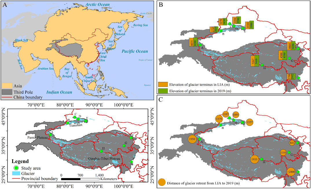
青藏高原及周边高山地区统称为“第三极”地区,是除南北极外最大的冰川集中区。在全球气候变暖背景下,第三极地区正经历显著增温,气温上升加速了冰川消融,进而影响区域生态平衡。第三极冰川前缘作为海拔最高的陆地脆弱生境之一,对气候及冰川变化响应敏感。深入了解冰川前缘植被动态,对科学评估冰缘生态系统响应气候至关重要。然而,受制于观测条件,目前仍缺乏对该地区冰缘植被的大范围系统性观测研究。 中国科学院西北生态环境资源研究院上官冬辉研究员团队与兰州交通大学、中巴地球科学联合研究中心及南通大学相关研究团队合作,选取第三极地区9条代表性冰川,在其前缘布设样地并获取植被信息。利用植被指数量化了冰川退缩时间序列上植物群落特征的变化,并结合植物区系相似性指数,系统分析了不同样地间及不同冰川前缘间的植物区系相似性。 研究显示,物种多样性和植被盖度沿冰川退缩时间序列呈波动增加趋势,且在海洋性冰川前缘的增加速率尤为显著。所有冰川前缘的植物生活型在演替早期阶段较为相似,但随着演替推进,生活型组成开始分化,在不同类型冰川前缘间差异更为明显。此外,不同冰川前缘间具有植物区系相似性,其中地理位置邻近且属于同一类型冰川的前缘地区植物区系相似性最高。 该研究揭示了局地气候与地理因子在塑造冰川前缘生态系统及植物区系格局中扮演的关键作用,为阐明气候变化对冰川前缘生态系统的影响提供了科学依据,并为区域生物多样性保护工作提供了理论指导。 该成果以Vegetation successional dynamics and floristic similarity across various glacier forelands in the third pole为题发表于国际知名学术期刊Global and Planetary Change上。兰州交通大学魏天锋副教授为本文第一作者,西北研究院上官冬辉研究员为本文通讯作者。研究得到中国科学院战略性先导科技专项(A类)和国家自然科学基金等项目的资助。 论文链接:https://doi.org/10.1016/j.gloplacha.2025.104916 (A)研究区地理区位图,(B)被研究冰川在小冰期和2019年的冰川末端海拔,(C)被研究冰川在小冰期至2019年间的冰川退缩距离
2025-06-09 中国科学院西北生态环境资源研究院Glacier forelands provide ideal natural laboratories for studying primary vegetation succession. However, understanding of vegetation dynamics on glacier forelands in the Third Pole (TP) region remains limited. In this study, we employed field sampling and aerial photography to investigate key vegetation parameters (species composition, species diversity, and fractional vegetation cover (FVC)) along chronosequences on nine representative glacier forelands of the TP, spanning continental, subcontinental, and maritime glacier types, then analyzed vegetation changes along successional gradients and assessed floristic similarity both within and among the glacier forelands. Our results showed that species diversity and FVC generally exhibited increasing trends, with fluctuations from young to old forelands. These parameters increased more rapidly on maritime glacier forelands. Plant life-forms were similar during the early stages across all forelands but began to diverge as succession progressed, particularly between different glacier types. Furthermore, floristic similarity was observed between glacier forelands, with the highest similarity occurring between forelands of the same glacier type in adjacent geographic locations. Our findings highlight the critical roles of local climate and geographic factors in shaping proglacial ecosystems and flora, providing a scientific basis for understanding the effects of climate change on proglacial ecosystems and guiding biodiversity conservation efforts.
The permanently shadowed regions of the lunar South Pole have become a key target for international lunar exploration due to their unique scientific value and engineering challenges. In order to effectively screen suitable landing zones near the lunar South Pole, this research proposes a comprehensive evaluation method based on a self-organizing map (SOM). Using multi-source remote sensing data, the method classifies and analyzes candidate landing zones by combining scientific purposes (such as hydrogen abundance, iron oxide abundance, gravity anomalies, water ice distance analysis, and geological features) and engineering constraints (such as Sun visibility, Earth visibility, slope, and roughness). Through automatic clustering, the SOM model finds the important regions. Subsequently, it integrates with a supervised learning model, a random forest, to determine the feature importance weights in more detail. The results from the research indicate the following: the areas suitable for landing account for 9.05%, 5.95%, and 5.08% in the engineering, scientific, and synthesized perspectives, respectively. In the weighting analysis of the comprehensive data, the weights of Earth visibility, hydrogen abundance, kilometer-scale roughness, and slope data all account for more than 10%, and these are thought to be the four most important factors in the automated site selection process. Furthermore, the kilometer-scale roughness data are more important in the comprehensive weighting, which is in line with the finding that the kilometer-scale roughness data represent both surface roughness from an engineering perspective and bedrock geology from a scientific one. In this study, a local examination of typical impact craters is performed, and it is confirmed that all 10 possible landing sites suggested by earlier authors are within the appropriate landing range. The findings demonstrate that the SOM-model-based analysis approach can successfully assess lunar South Pole landing areas while taking multiple constraints into account, uncovering spatial distribution features of the region, and offering a rationale for choosing desired landing locations.
The global cryosphere is retreating under ongoing climate change. The Third Pole (TP) of the Earth, which serves as a critical water source for two billion people, is also experiencing this decline. However, the interplay between rising temperatures and increasing precipitation in the TP results in complex cryospheric responses, introducing uncertainties in the future budget of TP cryospheric water (including glacier and snow water equivalents and frozen soil moisture). Using a calibrated model that integrated multiple cryospheric-hydrological components and processes, we projected the TP cryospheric water budgets under both low and high climatic forcing scenarios for the period 2021-2100 and assessed the relative impact of temperature and precipitation. Results showed (1) that despite both scenarios involving simultaneous warming and wetting, under low climatic forcing, the total cryospheric budget exhibited positive dynamics (0.017 mm yr-1 with an average of 1.77 mm), primarily driven by increased precipitation. Glacier mass loss gradually declined with the rate of retreat slowing, accompanied by negligible declines in the budget of snow water equivalent and frozen soil moisture. (2) By contrast, high climatic forcing led to negative dynamics in the total cryospheric budget (-0.056 mm yr-1 with an average of -1.08 mm) dominated by warming, with accelerated decreases in the budget of all cryospheric components. These variations were most pronounced in higher-altitude regions, indicating elevation-dependent cryospheric budget dynamics. Overall, our findings present alternative futures for the TP cryosphere, and highlight novel evidence that optimistic cryospheric outcomes may be possible under specific climate scenarios.
The presence of water in lunar materials can significantly impact the evolution of lunar geology and environment, as well as provide necessary conditions for the utilization of lunar resources. However, due to the limitations of lunar remote sensing methods, it is challenging to obtain direct evidence of water or determine its form of occurrence. Laser Raman spectroscopy, on the other hand, can provide valuable information on the type, distribution, and content of water in lunar materials without the need for illumination, sample pretreatment, or destructive measures. In this study, we utilized Raman spectroscopy to detect and quantify the water-containing characteristics of typical lunar rocks and minerals, including adsorbed water, ice, crystalline water, and hydroxyl-structured water. First, we used a 532 nm laser micro-Raman spectroscopy to identify and analyze the water-containing signals of various forms of water in lunar soil simulants. We then examined and analyzed the detection limits of adsorbed water, crystalline water, and hydroxyl- structured water in these simulants, as well as the relationship between their content and signal intensity. Finally, we employed linear regression (LR), ridge regression (RR), and partial least squares regression (PLSR) to quantitatively analyze the contents of these three forms of water in the lunar soil simulants. Our results demonstrate that the characteristic spectral peaks of the four forms of water in the lunar soil simulants can be clearly identified, with peak distribution regions located at 100-1 700 cm(-1) and 2 600-3 900 cm(-1) for the lunar soil components and water bodies, respectively. The spectral peaks of water are a combination of broad envelope peaks of hydrogen-bonded OH and sharp peaks of non- hydrogen-bonded OH stretching vibrations in varying proportions. The detection limits for adsorbed water, crystalline water (MgSO47H(2)O), and hydroxyl water (Al2Si2O5(OH)(4)) in the lunar soil simulants are 1.3 wt%, 0. 8 wt%, and 0. 3 wt%, respectively. There is a linear relationship between the intensity of water-containing peaks and the water content in the lunar soil simulants, with root mean square errors of 1. 75 wt%, 1. 16 wt%, and 1. 19 wt% obtained through LR, RR, and PLSR.
It is ofgreat significance for human to find the direct evidence of water existing on the Moon and understand the Moon better. China plans to launch the Chang'e-7 probe to carry out unmanned sampling and in-situ analysis in the Lunar south pole. In order to ensure the success of the mission, it is necessary to carry out sampling simulation experiments adequately on the ground. However, the simulation of water-bearing lunar regolith is the basis for the experiment. In this paper, the simulation and preparation process of water-bearing lunar regolith are studied in terms of the physical and mechanical properties. The uniformity of water distribution and low temperature water migration characteristics of water-bearing lunar regolith is analyzed. On the basis, the mechanical properties of the water-bearing lunar regolith are tested. The mechanical properties such as compressive strength, tensile strength and shear strength of the water-bearing lunar regolith are obtained, which provides the polar sampling tests.
The lunar environment is known to be characterized by complex interactions between plasma, the exosphere, dust, and the surface. However, our understanding of the environment is limited due to the lack of experimental evidence. Here, we propose a small, low-cost mission to characterize the dust and exosphere environment of the Moon. Named the Limb Pathfinder (LimPa), this is a proof-of-concept mission aimed toward understanding the coupling between plasma, dust, and tenuous neutral atmosphere. The LimPa mission was proposed to a call for the Small Mission to the Moon issued by European Space Agency in 2023. LimPa is designed to examine the dust exosphere above the lunar polar regions by using an utterly novel remote-sensing technique to measure the solar wind hydrogen atoms-the solar wind protons that are neutralized to hydrogen atoms. Its goals are (1) to detect for the first time the neutralized solar wind hydrogen produced by exospheric gas and levitated dust; (2) to measure the height profiles of the levitated dust and exospheric gas densities; and (3) to determine the emission mechanism of the horizon glow. Our baseline design of the LimPa mission is a 12U CubeSat. Three highly matured instruments are used: an energetic neutral atom camera, a proton sensor, and a camera system. The LimPa CubeSat is proposed to be inserted into a circular lunar polar orbit, with an altitude of 100 km as a baseline. The Sun-pointing attitude will allow measurements of neutralized solar wind that are produced by the exosphere and dust grains above the polar regions. The nominal lifetime is for 3 months as a pathfinder mission. The LimPa mission will open a new window to remote characterization of the lunar dust exosphere environment above the poles, and will demonstrate that this monitoring can be achieved with a simple and low-cost instrument system and spacecraft operation. The concept to be proven by the LimPa mission will enable long-term monitoring of the fragile dust exosphere environment, which substantially impacts on lunar exploration and will be significantly altered by human activities.

