Surface soil moisture (SSM) is a key limiting factor for vegetation growth in alpine meadow on the Qinghai-Tibetan Plateau (QTP). Patches with various sizes and types may cause the redistribution of SSM by changing soil hydrological processes, and then trigger or accelerate alpine grassland degradation. Therefore, it is vital to understand the effects of patchiness on SSM at multi-scales to provide a reference for alpine grassland restoration. However, there is a lack of direct observational evidence concerning the role of the size and type of patches on SSM, and little is known about the effects of patches pattern on SSM at plot scale. Here, we first measured SSM of typical patches with different sizes and types at patch scale and investigated their patterns and SSM spatial distribution through unmanned aerial vehicle (UAV)-mounted multi-type cameras at plot scale. We then analyzed the role of the size and type of patchiness on SSM at both patch and plot scales. Results showed that: (1) in situ measured SSM of typical patches was significantly different (P < 0.01), original vegetation patch (OV) had the highest SSM, followed by isolate vegetation patch (IV), small bare patch (SP), medium bare patch (MP) and large bare patch (LP); (2) the proposed method based on UAV images was able to estimate SSM (0-40 cm) with a satisfactory accuracy (R-2 = 0.89, P < 0.001); (3) all landscape indices of OV, with the exception of patch density, were positively correlated with SSM at plot scale, while most of the landscape indices of LP and IV showed negative correlations (P < 0.05). Our results indicated that patchiness intensified the spatial heterogeneity of SSM and potentially accelerated the alpine meadow degradation. Preventing the development of OV into IV and the expansion of LP is a critical task for alpine meadow management and restoration.
Ice records provide a qualitative rather than a quantitative indication of the trend of climate change. Using the bulk aerodynamic method and degree day model, this study quantified ice mass loss attributable to sublimation/evaporation (S/E) and meltwater on the basis of integrated observations (1960-2006) of glacier-related and atmospheric variables in the northeastern Tibetan Plateau. During 1961-2005, the average annual mass loss in the ice core was 95.33 +/- 20.56 mm w.e. (minimum: 78.97 mm w.e. in 1967, maximum: 146.67 mm w.e. in 2001), while the average ratio of the revised annual ice accumulation was 21.2 +/- 7.7% (minimum: 11.0% in 1992, maximum 44.8% in 2000). A quantitative formula expressing the relationship between S/E and air temperature at the monthly scale was established, which could be extended to estimation of S/E changes of other glaciers in other regions. The elevation effect on alpine precipitation determined using revised ice accumulation and instrumental data was found remarkable. This work established a method for quantitative assessment of the temporal variation in ice core mass loss, and advanced the reconstruction of long-term precipitation at high elevations. Importantly, the formula established for reconstruction of S/E from temperature time series data could be used in other regions.
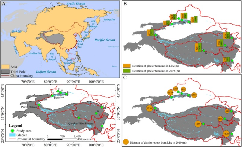
Glacier forelands provide ideal natural laboratories for studying primary vegetation succession. However, understanding of vegetation dynamics on glacier forelands in the Third Pole (TP) region remains limited. In this study, we employed field sampling and aerial photography to investigate key vegetation parameters (species composition, species diversity, and fractional vegetation cover (FVC)) along chronosequences on nine representative glacier forelands of the TP, spanning continental, subcontinental, and maritime glacier types, then analyzed vegetation changes along successional gradients and assessed floristic similarity both within and among the glacier forelands. Our results showed that species diversity and FVC generally exhibited increasing trends, with fluctuations from young to old forelands. These parameters increased more rapidly on maritime glacier forelands. Plant life-forms were similar during the early stages across all forelands but began to diverge as succession progressed, particularly between different glacier types. Furthermore, floristic similarity was observed between glacier forelands, with the highest similarity occurring between forelands of the same glacier type in adjacent geographic locations. Our findings highlight the critical roles of local climate and geographic factors in shaping proglacial ecosystems and flora, providing a scientific basis for understanding the effects of climate change on proglacial ecosystems and guiding biodiversity conservation efforts.
The glaciers in the Sawir Mountains, Altai area, have been experiencing a continuing and accelerating ice loss since 1959, although the snowfall is abundant and evenly distributed over the year. As an attempt to reduce their melting, we carried out two artificial snowfall experiments on the Muz Taw Glacier during 19-22 August 2018. We measured the albedo and mass balance at different sites along the glacier before and after the experiments. Two automatic weather stations (AWSs) were set up at the equilibrium line altitude (ELA) of the glacier as the target area and the forefield as the control area to record the precipitation, respectively. A comparison of the two precipitation records from the two AWSs suggests that natural precipitation could account for up to 21 % of the snowfall received by the glacier during the experiments. Because of the snowfalls, the glacier's surface albedo significantly increased in the middle to upper part; the average mass loss during 18-24 August (after the experiments) decreased by between 32 and 41 mm w e (14 %-17 %) compared to during 12-18 August (before the experiments); and the mass resulting from the snowfall accounted for between 42 % and 54 % of the total melt during 18-24 August. We also propose a mechanism involving artificial snowfall, albedo, and mass balance, and the feedbacks describing the role of snowfall in reducing the melting of the glacier. The current status of the work is primitive as it is a preliminary trial, and the conclusions need more controlling experiments to validate it against larger spatio-temporal scales in future.
Study area: Urumqi Glacier No.1 Catchment in central Asia. Study focus: Chemical weathering at the basin scale is important process for understanding the feedback mechanism of the carbon cycle and climate change. This study mainly used the actual sampling data in 2013, 2014, and 2016, and the first collection from the literature in same catchment to analyze the seasonal and interannual characteristics of meltwater runoff, as well as cation denudation rate (CDR). New hydrological insights for the study region: The dominant ions of meltwater runoff are Ca2 +, HCO3- , and SO42-, which are mainly derived from calcite dissolution, feldspar weathering and sulfide oxidation. Meltwater runoff at Urumqi Glacier No.1 has higher concentrations of Ca2+ and lower concentrations of HCO3- than that from glaciers in Asia. Compared to 2006 and 2007, cation concentrations increased in 2013 and 2014, while SO42- concentration decreased. The daily ion concentration has seasonality and exhibits a negative relationship with discharge. Daily CDR is positively related to discharge and temperature. Annual CDR values range from 12.34 to 19.04 t/ km2/yr in 2013, 2014, and 2016, which are 1-1.7 times higher than those in 2006 and 2007 and higher than some glaciers in Asia. These results indicate that chemical weathering rate in the Urumqi Glacier No.1 catchment has increased with climate warming, and it is stronger than that of some glaciers in the Tibetan Plateau and surroundings.
With the global climate change, glaciers on the Qinghai-Tibet Plateau (QTP) and its adjacent mountainous regions are retreating rapidly, leading to an increase in active rock glaciers (ARGs) in front of glaciers. As crucial components of water resources in alpine regions and indicators of permafrost boundaries, ARGs reflect climatic and environmental changes on the QTP and its adjacent mountainous regions. However, the extensive scale of rock glacier development poses a challenge to field investigations and sampling, and manual visual interpretation requires substantial effort. Consequently, research on rock glacier cataloging and distribution characteristics across the entire area is scarce. This study statistically analyzed the geometric characteristics of ARGs using high- resolution GF-2 satellite images. It examined their spatial distribution and relationship with local factors. The findings reveal that 34,717 ARGs, covering an area of approximately 6873.54 km2, with an average area of 0.19 +/- 0.24 km2, a maximum of 0.0012 km2, and a minimum of 4.6086 km2, were identified primarily in north-facing areas at elevations of 4300-5300 m and slopes of 9 degrees-25 degrees, predominantly in the Karakoram Mountains and the Himalayas. Notably, the largest concentration of ARGs was found on north-facing shady slopes, constituting about 42 % of the total amount, due to less solar radiation and lower near-surface temperatures favorable for interstitial ice preservation. This research enriches the foundational data on ARG distribution across the QTP and its adjacent mountainous regions, offering significant insights into the response mechanisms of rock glacier evolution to environmental changes and their environmental and engineering impacts.
A novel actinomycete, strain 1_25(T), was isolated from soil under a black Gobi rock sample from Shuangta, PR China, and characterized using a polyphasic taxonomic approach. The results of comparative analysis of the 16S rRNA gene sequences indicated the 1_25(T) represented a member of the genus Streptomyces. Chemotaxonomic data revealed that 1_25(T) possessed MK-9(H-8) as the major menaquinone. The cell wall contained LL-diaminopimelic acid (LL-DAP) and the whole-cell sugar pattern consisted of ribose, glucose and galactose. Major fatty acid methyl esters were observed to be iso-C-16:0 (23.6%), and anteiso-C-15:0 (10.4%). The genomic DNA G+C content of 1_25(T) was 69 mol%. The results of phylogenetic analysis based on 16S rRNA gene sequence indicated that 1_25(T) had high sequence similarity with Streptomyces qinglanensis 172205(T) (98.1%), Streptomyces lycii TRM 66187(T) (98 %), and Streptomyces griseocarneus JCM4580(T) (98 %). In addition to the differences in phenotypic characters, the average nucleotide identity (ANI) and digital DNA-DNA hybridization (dDDH) values between 1_25(T) and closely related species were below the recommended threshold values for assigning strains to the same species. The fermentation product of 1_25(T) in ISP2 had an inhibitory effect on Staphylococcus aureus. On the basis of these genotypic and phenotypic characteristics, strain 1_25(T) (=JCM 34936(T)=GDMCC 4.216(T)) represents a novel species of the genus Streptomyces, for which the name Streptomyces gobiensis sp. nov. is proposed.
The Tibetan Plateau and its surroundings, also known as the Third Pole, play an important role in the global and regional climate and hydrological cycle. Carbonaceous aerosols (CAs), including black carbon (BC) and organic carbon (OC), can directly or indirectly absorb and scatter solar radiation and change the energy balance on the Earth. CAs, along with the other atmospheric pollutants (e.g., mercury), can be frequently transported over long distances into the inland Tibetan Plateau. During the last decades, a coordinated monitoring network and research program named Atmospheric Pollution and Cryospheric Changes (APCC) has been gradually set up and continuously operated within the Third Pole regions to investigate the linkage between atmospheric pollutants and cryospheric changes. This paper presents a systematic dataset of BC, OC, water-soluble organic carbon (WSOC), and water-insoluble organic carbon (WIOC) from aerosols (20 stations), glaciers (17 glaciers, including samples from surface snow and ice, snow pits, and 2 ice cores), snow cover (2 stations continuously observed and 138 locations surveyed once), precipitation (6 stations), and lake sediment cores (7 lakes) collected across the Third Pole, based on the APCC program. These data were created based on online (in situ) and laboratory measurements. High-resolution (daily scale) atmospheric-equivalent BC concentrations were obtained by using an Aethalometer (AE-33) in the Mt. Everest (Qomolangma) region, which can provide new insight into the mechanism of BC transportation over the Himalayas. Spatial distributions of BC, OC, WSOC, and WIOC from aerosols, glaciers, snow cover, and precipitation indicated different features among the different regions of the Third Pole, which were mostly influenced by emission sources, transport pathways, and deposition processes. Historical records of BC from ice cores and lake sediment cores revealed the strength of the impacts of human activity since the Industrial Revolution. BC isotopes from glaciers and aerosols identified the relative contributions of biomass and fossil fuel combustion to BC deposition on the Third Pole. Mass absorption cross sections of BC and WSOC from aerosol, glaciers, snow cover, and precipitation samples were also provided. This updated dataset is released to the scientific communities focusing on atmospheric science, cryospheric science, hydrology, climatology, and environmental science. The related datasets are presented in the form of excel files. BC and OC datasets over the Third Pole are available to download from the National Cryosphere Desert Data Center (https://doi.org/10.12072/ncdc.NIEER.db0114.2021; Kang and Zhang, 2021).
Indian monsoon circulation is the primary driver of the long-range transboundary mercury (Hg) pollution from South Asia to the Himalayas and Tibet Plateau region, yet the northward extent of this transport remains unknown. In this study, a strong delta Hg-202 signature overlapping was found between Lake Gokyo and Indian anthropogenic sources, which is an indicative of the Hg source regions from South Asia. Most of the sediment samples were characterized with relatively large positive Delta Hg-199 values (mean = 0.07 parts per thousand-0.44 parts per thousand) and small positive Delta Hg-200 values (mean = 0.03 parts per thousand-0.08 parts per thousand). Notably, the Delta Hg-199 values in the lake sediments progressively increased from southwest to northeast. Moreover, the Delta Hg-199 values peaked at Lake Tanglha (mean = 0.44 parts per thousand +/- 0.04 parts per thousand) before decreased at Lake Qinghai that is under the influence of the westerlies. Our results suggest that transboundary atmospheric transport could transport Hg from South Asia northwards to at least the Tanglha Mountains in the northern Himalaya-Tibet.
Study region: Urumqi River headwater region in eastern Tianshan, central Asia. Study focus: Climate change is anticipated to accelerate glacier shrinkage and alter hydrological conditions, causing variations in the runoff patterns in the catchment and significantly threatening the regional water resources. However, few models exhibit adequate performance to simulate both surface alterations and glacier/snow runoff. Therefore, this study combined the glacier module with the Soil and Water Assessment Tool (SWAT) model to estimate the effect of climate change on the streamflow in the Urumqi River headwater region. The Urumqi River Headwater region is representative because of its long data series, viatal location, and local water availability, and it contains the longest-observed reference glacier (Urumqi Glacier No.1) in China, which spans the period from 1958 to the present. New hydrological insights for the region: The SWAT model performed satisfactorily for both calibration (1983-2005) and validation (2006-2016) periods with a Nash-Sutcliffe efficiency (NSE) greater than 0.80. The water balance analysis suggested that the snow/glacier melt contributed approximately 25% to the water yield. At the end of the 21st century, the temperature would increase by 2.4-3.8 degrees C while the precipitation would decrease by 1-2% under two future scenarios (ssp245 and ssp585). Thus, a 34-36% reduction in streamflow was projected due to above climate change impacts. This information would contribute to the development of adaptation strategies for sustainable water resource management.
Permafrost carbon could produce a positive climate feedback. Until now, the ecosystem carbon budgets in the permafrost regions remain uncertain. Moreover, the frequently used models have some limitations especially regarding to the freeze-thaw process. Herein, we improved the IBIS model by incorporating an unfrozen water scheme and by specifying the parameters to estimate the present and future carbon budget of different land cover types (desert steppe, steppe, meadow, and wet meadow) in the permafrost regions. Incorporating an unfrozen water scheme reduced the mean errors in the soil temperature and soil water content by 25.2%, and the specifying leaf area parameters reduced the errors in the net primary productivity (NPP) by 79.9%. Further, the simulation results showed that steppes are carbon sources (39.16 gC/m(2)/a) and the meadows are carbon sinks (-63.42 gC/m(2)/a ). Under the climate warming scenarios of RCP 2.6, RCP 6.0, and RCP 8.5, the desert steppe and alpine steppe would assimilated more carbon, while the meadow and wet meadow were projected to shift from carbon sinks to carbon sources in 2071-2100, implying that the land cover type plays an important role in simulating the source/sink effects of permafrost ecosystem carbon in the IBIS model. The results highlight the importance of unfrozen water to the soil hydrothermal regime and specific leaf area for the growth of alpine vegetation, and present new insights on the difference of the responses of various permafrost ecosystems to climate warming.
The freeze-thaw (F-T) cycle of the active layer (AL) causes the frost heave and thaw settlement deformation of the terrain surface. Accurately identifying its amplitude and time characteristics is important for climate, hydrology, and ecology research in permafrost regions. We used Sentinel-1 SAR data and small baseline subset-interferometric synthetic aperture radar (SBAS-InSAR) technology to obtain the characteristics of F-T cycles in the Zonag Lake-Yanhu Lake permafrost-affected endorheic basin on the Qinghai-Tibet Plateau from 2017 to 2019. The results show that the seasonal deformation amplitude (SDA) in the study area mainly ranges from 0 to 60 mm, with an average value of 19 mm. The date of maximum frost heave (MFH) occurred between November 27th and March 21st of the following year, averaged in date of the year (DOY) 37. The maximum thaw settlement (MTS) occurred between July 25th and September 21st, averaged in DOY 225. The thawing duration is the thawing process lasting about 193 days. The spatial distribution differences in SDA, the date of MFH, and the date of MTS are relatively significant, but there is no apparent spatial difference in thawing duration. Although the SDA in the study area is mainly affected by the thermal state of permafrost, it still has the most apparent relationship with vegetation cover, the soil water content in AL, and active layer thickness. SDA has an apparent negative and positive correlation with the date of MFH and the date of MTS. In addition, due to the influence of soil texture and seasonal rivers, the seasonal deformation characteristics of the alluvial-diluvial area are different from those of the surrounding areas. This study provides a method for analyzing the F-T cycle of the AL using multi-temporal InSAR technology.